-
FAR NORTH CALLING
I’ve been to the northernmost parts of Norway twice already but I still felt a drag that pulls me back to these rough landscapes where you meet more reindeer than humans. On those earlier trips, I stuck to the main roads in Finnmark. This year I wanted to explore more remote areas, ride on quiet gravel roads and even do some hike-a-bike.
The trip took place in June, so this is not a live report and conditions might have changed since then. But I hope it will inspire others to ride the far north trails.
It takes some time to get there when you don’t want to fly and with only three weeks to spare. I chose the slow route – taking the boat from Germany to Helsinki, Finland, and then the next train north which brought me to Kajaani in the Middle of the country. Night trains will bring you even further North, all the way to the arctic circle.
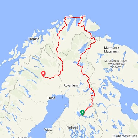
Since this forum is about cycling in Norway, I’ll focus on the Norwegian part of the trip, about 1000 kilometers from the Norwegian-Russian-Finnish tripoint up to the northernmost mainland lighthouse near Mehamn on Nordkyn peninsula, southwards on the scenic route Havøysund and the “Old Arctic Post Road” from Alta to Finland again.
Please click on “View more comments” to see the complete trip report
Route with POI’s https://ridewithgps.com/routes/51870578
ridewithgps.com
Kajaani - Finnmark - Gällivare
A trip along the Russian border, up to Europe's northernmost areas and south again on the Old Arctic Post Road - 2340.8 km, +16433 m. Bike ride in Kajaani, Pohjois-Suomi
 27 Comments
-
It took me a week to get to the tripoint. First, I rode on quiet roads to Suomussalmi where I entered Eurovelo 13 “Iron Curtain Trail” which goes all the way from South Finland to Norway. It mostly follows road 843 with little traffic but can get boring after while, and later it even follows main road E63 for a while. After I had passed the beautiful Hossa national park (worth stopping for a hike or a ride on a MTB trail), I turned right and cycled in a zigzag along the Russian border – on gravel in all different shapes and sizes. At Oulanka national park I rejoined the Eurovelo on road 950.
I saw lots of forest, lakes, rivers, swamps. The roads often follow the terrain, always up and down again but no significant climbs. -
The area along the Russian border is full of monuments and memorials reminding on difficult times. E.g. in 1940, tens of thousands of people built a 1200 km long defense wall against a possible Soviet invasion, and many of the massive rocks are still in place.
North of Sodankylä, I had to ride on E75 for 90 kilometers in lack of alternatives. The really interesting part began after Ivalo: The only road towards Kirkenes runs west along lake Inari (and it’s very scenic) but I turned east on road 969 towards Nellim. After many ups and downs it crosses the Paatsjoki river (Pasvikelva in Norwegian) 50 km east of Ivalo. The bridge offers a view to Russia, just a few hundred meters away. For the next 20 km, I had the winding gravel road all for myself until I reached the Finnish border zone which nobody is allowed to enter.
-
A 15 km long old border guard trail runs along it all the way to the tripoint. The trail alternates between easy stretches and brutally difficult sections: Big rocks, rotten duckboards, fallen trees, steep climbs, swamps … It won’t get boring, and the scenary is beautiful but it’s super exhausting. I took a break at the old border guard station in the middle of nowhere, and after seven hours I reached the place where Finland, Norway and Russia meet. I was welcomed by two young Norwegian soldiers who seemed a little surprised that someone with a bicycle turnes up from Finland at this place. We had a nice talk and they even offered to take my photo at “treriksrøysa”.
-
The tripoint itself isn’t very special besides you are not allowed to walk around the pile of stones or even touch it. Total count of visitors today: 11. For me, it felt like a small victory that I made it up there. Unfortunately, the path to the parking on the Norwegian side (5 km) starts very rocky, later it’s mainly (wet) duckboards, with Øre Pasvik national park to the left. I was quite exhausted when a beautiful reinbow showed up and made me smile again.
It was already getting late when I reached the parking and had dinner in a shelter. From there, a very nice gravel road runs north through the woods.
I pitched my tent near the Pasvik nature reserve. Fun fact: I had no reception for more than 24 hours during my hike-a-bike tour through no man’s land. Usually, you have reception even in very remote places in both Finland and Norway. -
Fv 8550 is the only road in Pasvik area, and it’s very bumpy. Traffic is low and slow. Occasionally, you’ll have a view to Russia on the other side of Pasvik river. My first stop was at “Infopunkt Gjøken”, a little outdoor exhibtion of historic buildings from the area including a rest stop with a fireplace. The parking is equipped with power outlets which I used to charge my phone.
Further north, I took a little detour to Skrøytnes birdwatching tower at the river. The road (Fv 361) is lined with wetland meadows which are covered in cotton grass. The short duckboard trail to the tower runs through thousands of cloudberry plants in full bloom. But I didn’t see many birds or other animals.
Next stop was the only supermarked in this area, coop in Svanvik, where I restocked my supplies and met more soldieres. Don’t worry, they have a base right nearby. And although everything here radiates calm, it’s quite soothing to meet politely greeting, relaxed soldiers.
-
North of Svanvik, the road gets much better and landscapes change on the leg towards Kirkenes where you ride along big lakes and along the impressive Langfjord. After two days in “the wilderness”, I didn’t enjoy the densly populated area around Hesseng where I turned on E6. When I had passed the airport and reach the big Korsfjord, I found “my inner peace” again: It was such a beautiful ride in the evening sun with reindeer all along the road. This is where I met Fetze on his way to Pasvik and Finland. His bike is definitely more suited for rough terrain. We had a really nice talk until we eventuelly continued our rides under the midnight sun along Munkefjorden. When I arrived in Neiden, I enjoyed Skoltefossen and Neiden river in this magical light until I pitched my tent in the middle of the night.
-
Next morning, blue skies, warmth and mosquitoes awaited me while I was a bit dizzy because of the short “night”. Perfect timing for a refreshing (and necessary) bath in the rapids. Just a few hundred meters away, I stopped at the “Ä´vv Skolt Sami Museum”. They have a well made exhibition and even built a replica of a old Neiden river boat. The boats were custom-made for the different conditions and use cases of each river. Now you can use this boat for free, it’s located at the open air museum area Skoltebyen near Skoltefossen.
E 6 runs along big swamp areas until Bugøyfjord. An employee of the museum recommended a hike to Saviostolen. It’s a stone on a little mountain that is formed like a seat. Sami artist John Savio used to walk up here and get inspired from the stunning views of both swamp land (with lots of reindeer) and the fjord. It was a great change of perspective.
When I continued the ride in late afternoon, temperatures had dropped a lot, and a strong headwind slowed me day. But I didn’t care about the conditions when I reached Varangerfjorden. A ride on the winding road along this impressive fjord offers so many fantastic views, and sometimes it feels like cycling along the ocean, with big waves and no land in sight. -
0:09
-
I had a late dinner in a shelter at Varanger Sámi Museum. (I had visited the exhibition two years ago and warmly recommend it to everyone interested in the history of life along the fjord and Sami culture.) I was tempted to cycle wast on E 75 towards Vardø (had been there last year) but went West instead. After a 160 m climb I reached the valley of Tana river with large sandbanks and the impressive Tana bru, one of only a few bridges along this river. I pitched my tent long after midnight above the riverbanks. The atmosphere is very different from the ride along the fjord: The water flows quietly, and even the seagulls on a sandbank in the river seeem to enjoy the silence.
-
Obviously, the human body needs some rest occasionally, so I didn’t had a bad conscious waiting for some rain showers to pass until got on my bike again around noon. The new day’s goal: To get as far north as possible because I didn’t want to get in a hurry the next day to reach the Havila kystruten boat in Mehamn.
At Rustefjelbma (coffee and snacks at the gas station), road 98 turns west and goes up and down a lot, offering various views on lakes and fjords. I met a fellow Dutch cyclist who told me about cold and raining conditions he had experienced the last days. But now, contrary to the weather forecast, the rain clouds vanished and the sun showed up. Perfect timing for my next stop: A 2,3 km hike to Rullesteinfjæra, a beach full of pebbles in all kind of shapes and colors, located at Tanafjorden. It’s a hike “over rough and smooth” but worth the trouble. The bay is surrounded by impressive mountains on both sides, the waves spoil the stones all the time, making them shine in bright colors in the sunlight. Every wave creates a new scenery, and on the way back, the make the pebbles clicking against each other. I spent more than an hour watching the scenery and enjoying the very special atmosphere.
-
I was way behind schedule, and when I started the 300 meter climb up to Ifjordfjellet, the evening raking light already illuminated the scenery, with lots of reindeer along the road, some patches of snow and ice at the top, and breathtaking views.
At Ifjord, I turned north on road 888 which winds along Laksefjord for 33 km. The midnight sun accompanied me until the road left the fjord and turns to the next mountain pass. I was too exhausted for the whole climb of 350 meters, so I was happy when I found a nice spot in Lanfjorddalen/ Laggu Nature reserve.
-
I had a good night of sleep, but when I woke up, a snow shower hit the tent, and temperature had dropped a lot. Well, of course I knew that conditions could be rough up here – although I hoped for something else. So I put on all clothes I had and faced the strong and cold wind from the North which would challenge me all day.
At the top of the first mountain plateau the road winds along Reinoksevannet which is still partly covered by ice with patches of snow all over the area. Low hanging, dark clouds created a really rough scenery, and some hail showers stressed that this is (fascinating but) an inhospitable place. Eventually, after a long stretch on the mountain plateau, a quite steep downhill brought me down to sea level again, to a small patch of land between Eidsfjord and Hopsfjord which makes Nordkynhalvøya a peninsula. On the other side of this valley, another steep clim awaits, leading to another mountain plateau which is covered by patches of ice and snow. Hail showers alternate with sunshine which gives a varied picture of the landscape. Think positive 🙂
Fun fact: Until 1989, the inhabitants of Nordkyn had to take the ferry boat to leave the peninsula, and in winter the road is still closed sometimes. -
A long downhill section ends in the little town of Mehamn where I took a break in the warming sun before the next leg, a “little detour” to the northernmost light house on the European mainland. Little did I think about the elevation gain when I added Slettnes fyr to the trip in Koomot: It’s more than 50 kilometers and 850 meter elevation gain. The road goes up and down all the time, with beautiful views of the Barents Sea, majestic valleys and many, many reindeer all over the place. On the final stretch from the village Gamvik to the lighthouse, landscape is totally clean, and at the end you see the endless ocean. I was so happy I made it there before the recently renovated café in the lightkeeper’s house closed. But doors were locked. Frustration was huge when I stood there in the cold wind, exhausted after the long battle with the elements. I was already mentally preparing for the long ride back to Mehamn when a young woman came running, opened the door and gave me a warm welcome. Sitting in the warm and cozy café with some coffee and sweat treats with a view on the rough ocean was just the best.
-
A local told me that it might happen that the boat won’t stop in Mehamn today due to high waves. In that case, I would have to cycle another 30 km over the mountains to Kjøllefjord.
Unfortunately, the local was right: Just after midnight, the receptionist from the Havila kystruten boat that should pick me up at 1.30 a. m. called and told me that they won’t make it to Mehamn due to high waves. So I packed my stuff, put all warm and rain clothes on and cycled 30 km to Kjøllefjord – another 400 m elevation gain. Sometimes it was difficult to see if it’s an uphill section or just very strong wind that wants to stop me 😬
“Havila Pollux” was already waiting for me, when I reached Kjøllefjord at 3.30 a.m., wet and exhausted. At least they gave me a cabin as compensation.
-
After a shower, a little nap and a shaky ride, I left the boat very groggy only 5 hours later in the little fishing village Havøysund. I grabbed a free coffee and some pastry at the local supermarket to awake the spirits and hit the scenic road 889. It was still cold and wet but at least now I had tailwind 😊
The road mostly runs along the coastline but also includes two mountain passes – not very high but In a harsh environment. I met a group of cyclists from the US on their way to Nordkap on one of these passes. They had all their luggage on trailers and were really struggling with the cold wind on a looong uphill section.
Cycling along this rugged coastline with a view on the raging sea and dark clouds was quite an experience. Nature even build some impressing “sculptures”. One of them is called “the sphinx” or “Lion of Måsøy”.
Right before Koelv, the road leaves the coast and crosses the whole Porsanger peninsula. I took a long coffee break at Russenes Kro in Olderfjord and finished the day with a stretch on E 6 to Skaidi.
What a day! I think I’ve never felt the power of nature so intense before. And for the first time on this trip, I felt my legs longing for some rest.
-
I thought that I deserved some rest, but at 7 o’clock a helicopter started loading building materials every few minutes right behind my tent. Today’s “only” task was to cross Sennalandet between Skaidi and Alta. A ride over this mountain plateau is something special. No trees, no bushes, snow patches everywhere and wide views. I met some flocks of reindeer and maybe even more cyclists on their way to North Cape 😊
Wenn I rolled down to Alta, I saw the first blue skies since days, and it somehow marked the end of this rough adventure on the peninsulas around North cape 😎It was very late again when I found a place for the night near Altaelva (Alta River) south of the city, where many people were still fishing in this shortest night of the year.
-
Gravel ahead! At Gargia mountain lodge, the 100 km gravel section of the “Old Arctic Post Road” begins. It starts with a steep 300m climb (which should scare off all campervan driver but doesn’t), and after 4,5 km I reached the hiking path to Alta Canyon. It’s a 6,3 km walk to one of North Europe’s biggest ravines, and it’s marked a as a “Medium MTB trail”. Well, I parked my bike after 100 meters. It’s worth the detour: Panoramic views, a nice waterfall, a few stream crossings until I found myself at the edge of the canyon, with Ata river floating 100 meters below.
After 3,5 hours I was back on the road over Bæskades mountain range. It’s over 200 years old, and it’s framed by stone claims to mark the winter post route. It runs through a barren landscape, with wide views on snow covered mountains. I took a long break at the café at Suolovuopmi fjellstue where I had an interesting conversation with a saleswoman who travels across the country every year to offer souvenirs to places like this.
-
When I hit the road again, road conditions changed: After some soft but mostly okay gravel in the northern part, now it quickly went more difficult: The surface was washed out many places, and loads of big stones and many potholes made me get of my bike several. The surrounding swamps were very wet, and so was the road. In a constant change, I rode and pushed my bike through river-like passages every few hundred meters. I met two other bikepackers this evening, and they also seemed a bit surprised by the road conditions. But the weather was fine; with blue skies for the whole afternoon. And the views were great! I saw the midnight sun shining above rivers and lakes in an absolutely quiet scenery.
-
The second day on the Arctic Post Road started with good news: About 20 km before the road connects to road E 45 again, conditions improved a lot; you could see it has been maintained.
I took a long stop or break in Kautokeino where I visited Juhls’ Silver Gallery. Impressing architecture and art. At the Rema supermarked (free coffee!), I met two bikepackers: One of them started in the very South of Europe two month agos and was now on his final stretch to North Cape. Later, I met a group of three from France. Not young anymore but already for months on the road.
I’m always impressed and inspired when people I meet on the road tell me their often quite wild stories.E 45 South of Kautokeino towards the Finnish border can get boring. But not for me, when a truck nearly pushed me from the road while passing by although oncoming traffic was already honking at him. So I was really happy when I left E 45 in Enontekiö and turned to a forest road leading to Pallas-Yllästunturi national park. I found a nice spot by a (very refreshing) lake.
-
The next days, I tried a MTB trail in the national park (which means: I pushed my bike for at least 20 km) and enjoyed some great views and the great infrastructure for hikers. After lots of gravel through beautful forests, I crossed the Swedish border near Kolari and cycled on endless roads west towards Gällivare where I entered Inlandsbanan train to Östersund. The next day, I took Snälltåget night train to Malmö. You don’t have many options when you want to take your bike in a train in Sweden but these trains always offer nice experiences and conversations.
-
Looking back, it’s been too many kilometers or too little time on this trip. I really enjoyed cycling at night, but I didn’t really take in account that the body needs some rest for regeneration. But it was totally worth the effort. I rode through very different landscapes (forests and swamps to barren mountains), experienced all kinds of weather (cycling under the warming midnight sun and over a cold and windy mountain pass in the rain), pushed my bike through rocky terrain and enjoyed finest gravel – and met reindeer almost every day. Go further North!
-

Thanks for sharing your adventure – sounds like an incredible trip and an amazing accomplishment! It’s such a challenging environment up there and a solitary journey alone. We should definitely feature it on the main website with the route and logistics to inspire others for years to come.
Let me know what works best from your side. From my side, I’ll need:
A route file with POIs on Ride with GPS
A logistics breakdown similar to the “Full Story” pages on the site
A route overview summary (max 500 words)
If you’d like, I can turn your day-by-day account into a blog post. I’ll use the photos you’ve already shared, so no need to upload them elsewhere.
-
And it’s great to have the whole route with Finland and Sweden. We certainly don’t want to only focus on Norway here. The whole route looks fantastic with so much on offer.
-
@Matthew Norway That’s a great idea 😊
Here comes the route: https://ridewithgps.com/routes/51870578
I’ll get back to you with all the details you asked for soon.
(I’m in the middle of a move which keeps me quiete busy 😬)
-
-
-
I have a really stupid question…how are you getting so many photos to upload? I sometimes can’t even get 1 photo to upload because of the image size straight from my iphone. It has stopped me from posting more than once haha.
-
@CChesnutt I had issues uploading photos on my winter trip in some remote areas. But this report is produced form home, so no issues with slow internet connections. Not sure if it’s related but @Matthew Norway posted something about an issue with file sizes that he had fixed now 🙂
-
@CChesnutt I have fixed the photo issue now. Try it out and see if you can upload more photos. Every photo should automatically reduce in size.
-
-
