Chatty Norway

Ask questions, find answers, and connect with our community from around the globe

News Feed Forums Does anyone know? Hike-a-bike from Finland to Norway in tri-border area near Øvre Pasvik

  • Hike-a-bike from Finland to Norway in tri-border area near Øvre Pasvik

    Posted by Michel on April 12, 2025 at 12:54 pm

    I’m planning a trip along EuroVelo 13 from Finland to Norway in June. But instead of cycling west of lake Inari and entering Norway at Näätämö/ Neiden (which is a wonderful route!), I’d like to cross the border at Treriksrøysa, the tri-border area where Norway, Finland and Russia meet, to get into Øvre Pasvik National Park and further north.
    I’m aware there is no road connecting Finland and Norway east of lake Inari but there are some hiking trails in that area: 35 km long Piilolan polku trail through Finnish Vätsärin
    national park is recommended for experienced hikers only – probably not a good option to hike-a-bike (see picture attached).
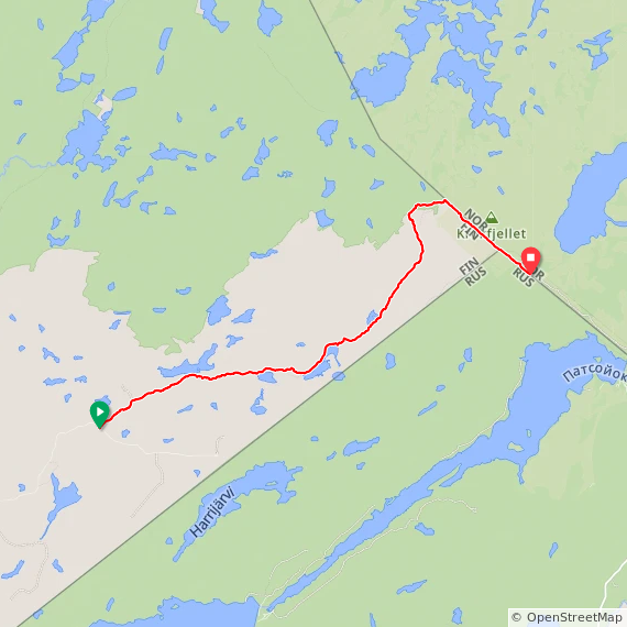
    But both Komoot and “Ride with GPS” show a 15 km long single trail south of it (see screenshot): https://ridewithgps.com/routes/50297715
    Unfortunately, finish tourist service didn’t know about this trail.

    Has anyone been in that area and knows about trail conditions?

    Eirik Kvisli replied 3 days, 23 hours ago 5 Members · 9 Replies
  • 9 Replies
  • Mike Page

    Member
    April 12, 2025 at 5:35 pm

    From RideWithGPS switch to Google Maps view. There is a photo point that pops up (Tripoint FI/NO/RU). Click on that and it opens Google maps and A LOT of photos from people who have been there at that intersection. Some photos show a long, wide path that’s probably the border.

    Contact some of the people who have posted those photos. Maybe they can help (at least they have been there).

    • Michel

      Member
      April 13, 2025 at 12:52 pm

      Hi Mike, that’s a good idea! I’ll try that, thank you 🙂

  • Matthew Norway

    Administrator
    April 12, 2025 at 5:54 pm

    @sykkeleirik may have some knowledge on this area.

    • Michel

      Member
      April 13, 2025 at 12:53 pm

      Hi Matthew, thank you, I’ll get in contact with Eirik 🙂

  • Thorsten Brandt

    Member
    April 13, 2025 at 5:12 pm

    I’ve been hiking at Øvre Pasvik (from my van) in early May (2012) and it was just coming to the end of the snow and ice, with the ground starting to thaw and everything being rather squelchy underfoot, but reindeer still standing on the river ice.

    What it’s going to be like a month later? Probably even squelchier?

    PS: I remember sending a text, and my phone deciding to log on to the Russian mobile network for that. Five quid, my most expensive SMS ever.

    • Michel

      Member
      April 13, 2025 at 8:11 pm

      Thanks, Thorsten! That’s good to know. I have read somewhere that it usually gets less wet in Mid June, after spring floods. But who knows what to expect for this summer? At least I expect to meet many mosquitoes 😣

      And thanks for the advice to turn of roaming on my phone 😱

      • This reply was modified 5 days, 13 hours ago by  Michel.
      • Thorsten Brandt

        Member
        April 13, 2025 at 9:42 pm

        Roaming is ok, just select a Norwegian or Finnish network, rather than letting the phone decide. 😀

  • Eirik Kvisli

    Member
    April 15, 2025 at 10:07 am

    I think that will be a very wet walk with a lot of vegetation on the finish side of the border. Getting to Treriksrøya from the Norwegian side is not so hard.

    https://youtu.be/DPRiL8qEOkc?si=T2isqSFbzOEKsq6r

  • Eirik Kvisli

    Member
    April 15, 2025 at 10:09 am

    from wikipedia:

    The tripoint can only legally be approached by the public from the Norwegian side, since both Finland and Russia maintain extensive border zones where public access is prohibited.

Log in to reply.

×

Premium Access Required

You need a premium membership to join this group or participate in this forum.

Upgrade Now